Today’s little foray into my life will consist of my experience hiking the Juan de Fuca trail on the west coast of Vancouver Island. As many of you know, I have occasionally enjoyed the hiking, so I thought for our first wedding anniversary this would be and interesting thing for Glen and I to do. We planned to park our car at the north end of the trail and take the shuttle to the south end, thus hiking back to the car. We were going to take 3 days to hike, staying 2 nights at campsites along the trail.
We caught the shuttle and were on the trail at 10 am. Everything was peachy as we came out onto Mystic beach. That was the last time anything could be referred to as peachy. The terrain got significantly worse from there. Here’s how it went: up a steep hill, down a steep hill, over a creek, repeat several times until exhaustion sets in. Then continue the pattern until you wish you were back at home. We were planning on staying at Chin beach the first night, which was 21 km from where we started, so after about an hour of this we knew we were going to have to go like stink. Plus when you realize it’s taking you about 30 minutes to go a mere 1 km, you start to think you might be in over your head, and that making Chin beach is just wishful thinking. But we hiked on.
We got to Bear beach and stopped to use the outhouse and have a snack. As we were about to leave, I realized my camera had fallen off my backpack somewhere along the beach. After searching for about 45 min, we gave up. In the process of searching, I tripped on a rock, fell onto a rock, and took a healthy chunk of skin off my right knee. With a lost camera and a bleeding knee, I decided I wasn’t having fun anymore.
We kept going down the beach and got to the end, and as we were looking for a sign to figure out where trail met beach, two fellows came along behind us. Glen asked them if they’d found a camera. Praise whatever god you pray to, they had found our camera! Things were starting to look up again. The next problem was finding the trail again. The map we had been looking at wasn’t very helpful, and we thought maybe it was farther along the beach. So the two Czech guys and us took our boots off and waded through this pool at the end of the beach, figuring the trail started again on the other side, and that the tide was just coming in. It wasn’t. We were lost. After some discussion and walking back along the beach again, we spotted a sign. It was through a creek and up a steep hill, but that’s where the trail went. So our next obstacle was crossing this stream. The bed of said stream was actually rock, which would’ve been fine, except there was this delightfully slimy moss growing on the rock, thus making the streambed extremely slippery. So you hold onto the rope and walk through the stream. Thankfully the water wasn’t very deep, and we were at least smart enough to wear our waterproof boots. However, the moss was very slippery, and I nearly lost it about halfway through. Thankfully I made it, and up another steep hill we went.
So many more exhausting hills later, we rolled into Chin beach at 7 pm. We pitched our tent and made dinner. One nice part of this trip was the other people camped at Chin. They helped up find a nice campsite, and as we were cooking dinner, invited us to join them at the fire they had going on the beach. That part of the trip was lovely, sitting near a nice fire with some good company and the waves crashing in the background.
Another cool part was the suspension bridges. They were a good 50-60 feet across, and suspended around 100 feet from the bottom of most of the ravines they went over.
The next morning we decided that we’d rather spend our next night in a hotel in Victoria, rather than camped in the bush somewhere. So we headed for the car. We made the excuse to ourselves that we would get to the last campsite and decide then if we would go all the way, but who were we really kidding? After all the bloodletting and near loss of camera? To make a long and painful story short, we got out of the bush at 9:30 that night, a full 12 hours after we walked off Chin beach that morning. For anyone doing the math, the trail itself is 47 km long, and our car was parked in Port Refrew, 3 km from the end of the trail. So we covered 21 km the first day, thus leaving about 26 that we covered the next day. Yes, we are insane.
We got lost twice the second day. Once, when we followed the wrong trail, ended up on a deserted beach, and had to backtrack to find the real trail again. The second time was basically the same, involving a beach and a serious lack of signs. Both times we wandered around for nearly an hour, trying to figure out where the trail started again. The first time I even started to freak out a little, since we were losing time and, well, completely lost. But we did eventually find our way.
So now I will go into detail about the little parts of the trail that I remember and that were the bane of my existence at the time.
The mud bogs. Every hiker’s seen them, and every hiker’s done the “dance around the edge” bit, to avoid having their boots sink up to their knees in muck. Well there were a lot of these. And when I say a lot, I mean one every few steps. No, not every few hundred steps, but every few steps. You’d just get around the last one, and take two steps and be on the next one. This is one of the reasons the going was so slow on the trail. So you might ask, why didn’t you get fed up and just start going straight through them after a while? Well, you do. For some of them. But others are so deep in the middle that you literally would sink up to your knees. So you continue the dance.
This was one of the more mild looking mud bogs. Note the unpleasant look on my sweetie's face.
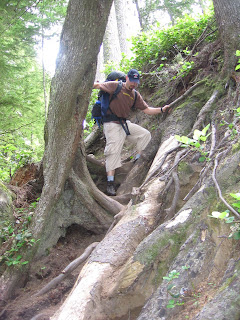
The bloody tree roots. Freakin tree roots! The ENTIRE trail was like this. I know on some trails the tree roots seem cool, and provide good stairs to climb up. But after 47 km of them, you start to get really sick of clambering over tree roots. And these aren’t your ordinary tree roots. These are west coast tree roots. Thus they are much, much bigger. You end up climbing 5 feet up one side of the tree root to climb right back down the other side. I clipped my knee on one the first day (the already injured knee, by the way), and the root almost made it bleed, and gave me a good bruise. One of those bruises that turns a beautiful purple and then goes yellow as it’s fading. And, similar to the mud bogs, the tree roots occur ever few feet. So you feel like all you’re doing is climbing over tree roots. Some of them are so steep you end up grabbing the nearest root or branch to help pull yourself up. And you know other people have done the same, since the branch you just grabbed has been worn smooth by other people grabbing the same spot. The tree roots slow you down, too.
A rather "easy" section of what the tree roots look like. Glen and I could teach a course on climbing around tree roots now.
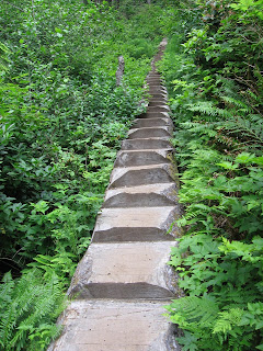
The stairs. The actually flights of stairs that have been built on this trail are fine. Actually, in parts they have used a previously fallen log and just chainsawed steps into them. Those steps are pretty cool. It’s the places where the park guys have taken a fallen log, driven two pieces of rebar into either end, and piled dirt up behind it on a slope that get to you. Normally, this is just good trail maintenance. It prevents erosion on slopes and makes it a little easier to hike. Not so on the Juan de Fuca. They’ve made all the steps too tall. I’m 6 feet, and I was having trouble getting up some of these. Now put a 40 lb pack on your back. Yeah. After a couple, I proceeded to whip out the “put one foot on the step, use your hand on your knee to help push yourself up” technique. Now do this several thousand times and you’ve got about half the trail.
The fallen trees. In some places, over the years, trees have fallen across the trail. Sometimes they have turned these trees into steps, bridges and whatnot. Other times they chainsaw through the whole thing. Most times, though, the tree is simply too large to chainsaw all the way through. What they do then is chainsaw steps up one side of the trunk and down the other. So there’s more steps you need to walk up and down. And they don’t make the steps small, either.
The underbrush. The Juan de Fuca trail is built in a coastal rain forest. And with this comes certain vegetation. And piles and piles of thick underbrush. The parks people have not cleared this underbrush from the trail. So for a large majority of the trail, you can see where the trail goes by looking at your feet, but when you look up, all you see is bush. Thick, leafy, tick-containing bush. After several kilometres I took to complaining about the bush. After several more kilometres, Glen asked me to stop, since it was getting annoying hearing me whine. I don’t blame him. Because of all the brush, there wasn’t much to see for the whole trail, so there wasn’t much to do other than complain.
The sweat. The trail is on the coast. Thus the air is extremely humid. And it was warm that weekend. So going up a steep hill (by now you know there were many of these), you break a sweat almost instantly. So after about 15 seconds, your clothes are soaked and you’re pretty much dripping. It was on this trail I decided fisherman’s hats are good, because once you sweat enough to soak the part that’s up against your forehead, you can turn the hat and the next part’s dry. It’s like having 4 hats in one. I have never sweated so much at one time in my life. And I`ve run a marathon.
I hated the two days I spent on this trail. We hiked it too fast, we didn’t expect the terrain we were on, I nearly lost my camera, we got lost twice, and I got hurt. It was a horrible 2 days. But Glen and I decided the next day, in our comfy, warm, clean Victoria hotel room, that to properly appreciate this trail you’d need to take your time. You’d have to stay one night at each camp and really, really take your time going between them. Then it might not be so bad. So to anyone thinking of hiking this trail, make sure you take your time and plan to spend almost a week there. Trust me, you’ll have a way better time.


